BAS 32037
Pontlatzer bridge
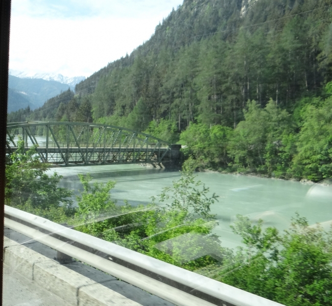
Pontlatzer Brücke
19.5.18
© Hannes Müller
Keine weiteren Bilder verfügbar
Austria
Tyrol
Fließ
Inn
Street
arch bridge, arch under the roadway
Steel
1899
0.00 m
0.00 m
0.00 m
0.00 m
0.00 m
0.00 m2
in operation
Wikipedia:<br>The Pontlatzer bridge is a bridge in the upper Tyrol's Inn Valley, North of the village of Prutz, approx. 12 km south of Landeck and is located at an altitude of 863 metres.<br>The Pontlatzer bridge was the official border between the former district of Ried until 1978 in the upper Inn Valley and the Court district of Landeck. The land that was the Court Ried, called still upper court.<br>Already the Roman via Claudia the Inn crossed the Pontlatzer bridge. The name is derived from "Pons Ladis", which means bridge of Ladis.<br>The bottleneck at the bridge offered an ambush for the defenders against Bavarian troops twice, in the war of the Spanish succession in 1703 and the Napoleonic wars 1809.<br>As 1703, the Bavarian elector Maximilian II Emanuel occupied Tyrol, a force marching in July to the Reschen pass was destroyed largely by 300 men by means of landslides and protect posted on the slopes. This success in small own losses was the signal for the uprising, and Max Emanuel, escaped on July 26, just from Innsbruck.<br>When Tyrol 1809 Bavarian troops invaded, on 8 and 9 July, between the bridges of Pontlatz and Prutz came into a carnage, in turn small losses under the Tyroleans. This battle is counted to the three big victories against Napoleon, but had not the importance of the battle of 1703 by far.<br>In memory of the two battles, a monument, erected in 1904 stands today at the Pontlatzer bridge. Today, the bridge is an iron arch bridge built in 1899 something further West, below flow are two typical covered wooden bridges. This bridge is also the eponym of Pontlatzkaserne in Landeck.
A map is loading