BAS 37793
I-35W bridge

Die Brücke vor dem Einsturz
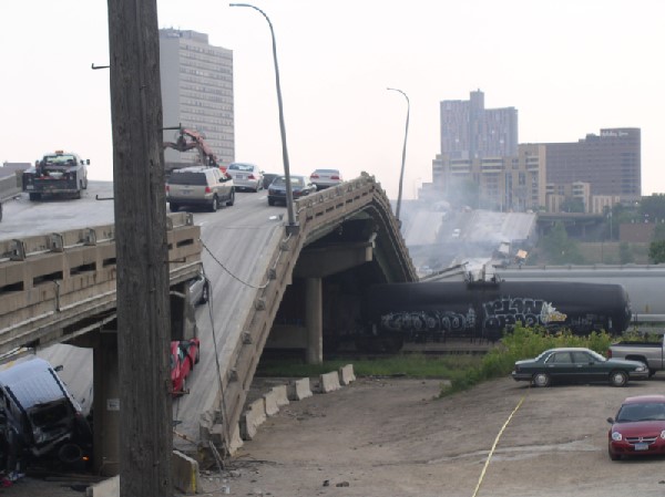
Die Brücke kurz nach dem Einsturz
01.08.2007
USA
Minnesota
St. Paul / Minneapolis
MississipPi
Interstate I35W, highway
Truss bridge
Steel, steel concrete driveways
1967
139.60 m
600.00 m
0.00 m
19.50 m
0.00 m
0.00 m2
destroyed
The bridge collapsed on August 1, 2007 at 6:05 PM. The cause is still unclear. (Presumably material fatigue due to inadequate maintenance
Official name (?): "Freeway Bridge"
The eight-lane bridge of Interstate 35 (I35W) in the US state of Minnesota connects the city of Minneapolis across the Mississippi River to the city of St. Paul. The Mississippi is 118.8 meters wide at this point, and the distance between the underside of the roadway and the water level is 19.5 meters. During inspections by the responsible authorities in 2001, 2005, and 2006, no serious defects were found, but "structural deficiencies" and "some signs of fatigue" were noted, and a new bridge was recommended as a precautionary measure. (Sources: Reuters, BBC, Star Tribune, Stern, N24)
Translated from current reports by KOLO-TV News (originally AP) by Ralf A. Flemming (as of August 2, 2007):
The bridge is The bridge is the busiest in the state and carries approximately 100,000 vehicles a day. The White House stated that problems were identified during a 2005 inspection of the bridge. According to transportation officials, the Interstate 35W bridge scored 50 on a 100 scale for "structural stability" and was classified as "structurally deficient." This rating means that some parts of the bridge were slated for repair or replacement and inspection every two years. "This does not mean the bridge is unsafe," said Transportation Secretary Mary Peters. White House Press Secretary Tony Snow had previously stated, after the inspection had already revealed the risk of the bridge failing, "When an inspection report identifies deficiencies, the state is responsible for the corrective action." Governor Tim Pawlenty ordered an immediate review of all bridges of similar design in the state on Thursday, but also said that The state was never warned that the bridge should have been closed or repaired immediately. "It was more a matter of monitoring, inspection, maintenance, and possible future repairs." Another, final inspection was scheduled for September. Several states surrounding Minnesota, including Arizona, Michigan, New Jersey, and New Mexico, ordered inspections of their own bridges.
The first step in the federal investigation will be to recover pieces of the bridge and piece them together like a puzzle to determine what happened, said NTSB Chairman Mark Rosenker. The collapse will also be examined using video footage, and a hotline has been set up for witnesses. "At this early stage of the investigation, it is far too soon to comment on the possible cause of this accident," Rosenker said.
In the days leading up to the collapse, road crews were working on the bridge's connections, guardrails, and lighting. As a result, some lanes were closed overnight. According to the Minnesota Department of Transportation, the bridge was Equipped in 2001 with an automated de-icing system that sprays chemicals onto the road surface during winter weather conditions, the bridge was originally built in 1967. The arched steel bridge spanned the river at a height of 19.5 meters, measuring 579.2 meters in length. It was constructed with a single, 139.6-meter-long steel arch to avoid the use of piers, which might have obstructed river navigation. According to the Army Corps of Engineers, the water depth under the bridge varies between 1.2 and 4.3 meters. "No one expected a collapse due to the impact of a collision with cargo and grain barges. The vast majority of the river is used by recreational boaters, while commercial vessels tend to use the docks further south," said Bill Gretten of the Army Corps of Engineers.
A map is loading