BAS 40514
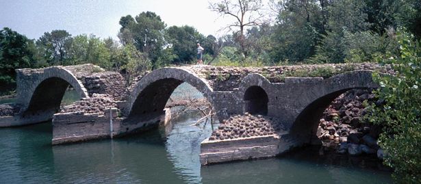
Pont Romain de Saint Thibéry
© Robert Cortright / Bridge Ink
Use of Robert Cortright
Keine weiteren Bilder verfügbar
France
Languedoc-Roussillon; Hérault (34)
Saint-Thibéry
Hérault
Way
arch bridge, arch under the roadway
Stone
römischen Ursprungs, zur Zeit Augustus (30 v. Chr.–14 n. Chr.)
0.00 m
0.00 m
0.00 m
0.00 m
0.00 m
0.00 m2
destroyed
Wikipedia:<br>The bridge had nine arches with a span of 10-12 m. The roadway rested on wide piers, which were reinforced to protect against flooding and washout with arc-shaped flood passages and powerful breakwaters at both ends.[2] The original length of the structure is estimated to be about 150 m, the road width to 4 m.[2] Parts of the bridge were destroyed at an unknown time before the year 1536 by a flood.[2]

The remaining arches show a visibly flatter contour gradient (115°) as a preferred otherwise by Roman bridge-builders, the arches (180°) with a wide to height ratio of minimum 3.3: 1.[1][2] The wall thickness of the individual vaults is moving at one-twentieth to one-tenth of the span in the normal range of Roman bridges.[3] The structure is dated to the reign of Augustus (30 BC - 14 ad); the Roman origin is however not without controversy
A map is loading